Mudumalai National Park forms an integral part of the Mudumalai Wildlife Sanctuary. It lies about 150 kilometres from Coimbatore in the Nilgiri District of Tamil Nadu and shares its boundaries with Karnataka and Kerala. Importantly, the Western Ghats region of the Nilgiris, covering nearly 6,000 square kilometres and including Mudumalai National Park, is under consideration as a UNESCO World Heritage Site. As a result, the park enjoys global attention for its ecological importance. Mudumalai offers a captivating mix of scenic landscapes, open grasslands, swamps, and dense forests. Moreover, it shelters rich biodiversity, including exotic flora, diverse wildlife, and rare bird species. Consequently, wildlife enthusiasts experience pure bliss while exploring this pristine natural haven.
Image Attribution: Jaseem Hamza
Major Tourist Attractions in Mudumalai
Mudumalai Wildlife Sanctuary
Mudumalai National Park holds the status of a designated Tiger Reserve. The name “Mudumalai” translates to “situated on the first hill.” Furthermore, the sanctuary is divided into five forest ranges—Masinagudi, Theppakadu, Mudumalai, Kargudi, and Nellakota. The terrain includes tropical moist deciduous forests, tropical dry deciduous forests, and southern tropical dry thorn forests.
In addition, the sanctuary shelters rare and iconic species such as the Asian elephant, tiger, leopard, gaur, sloth bear, hyena, grey langur, bonnet macaque, and numerous reptiles and birds. Theppakadu serves as the main entry point and houses an information centre for visitors.
Kalhatti Waterfalls, Mudumalai
Kalhatti Waterfalls stands out as an ideal trekking destination within Mudumalai. Located along the Ooty–Mysore route, the falls lie about 13 kilometres from Ooty. Situated on the slopes of the Kalhatti Hills at an altitude of nearly 2,000 metres above sea level, the waterfalls offer trekkers a thrilling experience combined with breathtaking natural beauty.
Theppakadu Elephant Camp
Theppakadu Elephant Camp derives its name from “Theppam,” meaning pond, and “Kaadu,” meaning forest. Although the camp has existed since 1910, authorities officially declared it an elephant camp in 1972. Here, caretakers train and house elephants, while visitors can enjoy elephant shows conducted every Saturday and Sunday. Elephant races and soccer matches performed by the elephants add a delightful charm to the experience.
Mudumalai Museum
The Mudumalai Museum is located near the elephant feeding camp. It showcases preserved specimens of animals that once inhabited the forest. Therefore, the museum offers visitors a valuable glimpse into the region’s wildlife history and remains a worthwhile stop during the visit.
Moyar River
The Moyar River originates near the town of Moyar along the Masinagudi–Ooty road and flows as a tributary of the Bhavani River.
Significantly, it forms the natural boundary between Mudumalai Sanctuary and Bandipur National Park in Karnataka.
Animals frequently gather along its banks to drink water.
Additionally, the Moyar River Gorge, also known as the Moyar Canyon, is a dramatic natural formation carved by the river over time. Here, the river plunges from a great height, creating the picturesque Moyar Falls.
Things to Do in Mudumalai
Visitors can also explore nearby forest reserves such as Bandipur National Park in Karnataka and Wayanad Wildlife Sanctuary in Kerala. Besides sightseeing, Mudumalai offers a variety of engaging activities that keep tourists immersed in nature.
- Canter and jeep safari
- Bird watching
- Camping amidst pristine surroundings
- Nature trails and photography
- Trekking to Moyar Gorge
- Village tours
- Elephant camp visits and elephant safari
- Watch tower and water hole exploration
Ideal time to visit Mudumalai
Mudumalai is an year-round destination but the best time to visit between the months of February to June. Vehicle Safari duration is for 1 hour –6 a.m. to 9 a.m. and 3 p.m.
How to reach Mudumalai
Mudumalai is connected via road to Gudalur (3 kilometres), Ooty (41 kilometres) and Mysore (84 kilometres).Taxi services are also available from Ooty to Mudumalai. The nearest railway station is Ooty station (40 kilometres) and the closest broad gauge station is Coimbatore Railway Station (116 kilometres). The nearest airport is the Coimbatore International Airport (123 kilometres). Accommodation is available at forest rest houses, guest houses at Masinagudi, kargudi, Theppakadu and Abhayaranyam.
Mudumalai National Park – FAQ
Where is Mudumalai National Park located?
Mudumalai National Park is located in the Nilgiri district of Tamil Nadu, at the tri-junction of Tamil Nadu, Kerala, and Karnataka. It lies along the foothills of the Western Ghats.
What animals can be seen in Mudumalai National Park?
The park is home to Bengal tigers, Asian elephants, Indian leopards, gaurs, sloth bears, spotted deer, and over 250 species of birds, making it a biodiversity hotspot.
What is the best time to visit Mudumalai National Park?
The best time to visit is from October to June when the weather remains pleasant and wildlife sightings are more frequent near water sources.
Is safari available in Mudumalai National Park?
Yes, visitors can enjoy jeep safaris and bus safaris organized by the Tamil Nadu Forest Department for wildlife spotting.
Is Mudumalai part of a larger tiger reserve?
Yes, Mudumalai National Park forms a part of the Nilgiri Biosphere Reserve and is included under the Mudumalai Tiger Reserve.
Nearby Tourist Attractions
Coonoor, the second-largest hill station in the Nilgiri Hills of the Western Ghats, charms visitors with its colonial heritage, lush green landscapes, and breathtaking viewpoints. Located at an altitude of 1,930 metres and just 19 kilometres from Ooty, Coonoor offers all the beauty of a classic hill station while remaining pleasantly less crowded. Moreover, sprawling tea plantations, misty Nilgiri hills, blooming valleys, and an old-world colonial ambience define the town’s unique appeal.
Major Tourist Attractions in Coonoor
Sim’s Park
Sim’s Park, named after Mr. J.D. Sim, a former secretary to the Government, was laid out in 1874. This park-cum-botanical garden showcases several rare species of plants and shrubs. Every year in May, tourists can witness the popular Annual Fruits and Vegetables Show. In addition, visitors can enjoy boating within the park, making it a relaxing family-friendly attraction.
Lamb’s Rock
Lamb’s Rock lies about 8 kilometres from the Coonoor town centre. Although trekking to the summit involves a steep climb, the effort is truly rewarding. From the top, visitors can admire magnificent views of the surrounding valleys and the distant Coimbatore plains.
Dolphin’s Nose, Coonoor
Situated 10 kilometres from Coonoor, Dolphin’s Nose Viewpoint is a prominent scenic spot. Notably, Lamb’s Rock lies along the road leading to this viewpoint. The flat, protruding rock resembles a dolphin’s nose, hence the name. From here, tourists can enjoy stunning sunrise and sunset views along with an unobstructed sight of the majestic Catherine Falls.
Catherine Waterfalls
St. Catherine Falls is located around 21 kilometres from Coonoor and 8 kilometres from Kotagiri. Nestled near Aravenu on the Kotagiri–Mettupalayam Road, this double-cascaded waterfall draws its waters from the Kallar River. Furthermore, Dolphin’s Nose offers a beautiful panoramic view of the falls.
Law’s Falls
Law’s Falls is an attractive natural spot located on the Mettupalayam–Coonoor–Ooty route. Situated nearly 10 kilometres from Coonoor, the waterfall is surrounded by vast stretches of dense forest, thereby offering a refreshing break for travellers.
Droog Fort
Droog Fort, located about 17 kilometres from Coonoor, is believed to have served as an outpost for Tipu Sultan. Also known as Bakasura Malai, local legends suggest that a demon once inhabited the fort. Today, it stands as a must-visit destination for trekkers, adventure seekers, and bird watchers. Tourists must travel up to Nonsuch Estate and then trek approximately 4 kilometres to reach the fort.
Things to Do in Coonoor
Tourists can enjoy a wide range of activities during their stay in Coonoor. Most importantly, trekking remains the most popular activity, offering rewarding experiences through viewpoints, tea estates, and waterfalls. Additionally, the iconic toy train ride from Coonoor to Ooty is an experience that should not be missed.
Shopping in Coonoor adds to the overall experience. Visitors can buy antique and exquisite handicrafts, apparel, embroidered shawls, Toda jewellery, aromatic tea, fresh honey, and homemade chocolates.
Ideal Time to Visit Coonoor
The peak tourist season in Coonoor extends from April to June. However, the best time to visit is from March to June and again during September and October, when the weather remains pleasant and the surroundings appear lush and vibrant.
How to reach Coonoor
Coonoor is well connected to all major cities by road. The nearest railway hubs to Coonoor are Mettupalayam (32 kilometres) and Coimbatore (68 kilometres). The nearest airport is at Coimbatore (68 kilometres).
Nearby Tourist Attractions
Valparai is a scenic hill station located in the Coimbatore District, rising more than 3,500 feet above sea level in the Anamalai mountain range. Nestled close to Pollachi, Valparai stands out with its lush green hills, cascading waterfalls, serene dams, and secluded valleys. Vast tea and coffee plantations stretch across the landscape, surrounded by dense forests, making Valparai an ideal destination for a peaceful and pollution-free getaway.
Situated about 100 kilometres from Coimbatore at an elevation of approximately 3,914 feet, Valparai offers a thrilling journey through nature. The route from Aliyar to Valparai features 40 hairpin bends within a 40-kilometre stretch, offering breathtaking views at every turn. Meanwhile, the Athirapally–Aliyar route frequently presents sightings of wild elephants, deer, bears, and occasionally leopards, especially along the Malakkappara–Valparai stretch.
Moreover, Malakkappara and Valparai together host some of the largest tea estates in India. Visitors can choose from budget homestays to heritage estate bungalows, ensuring a comfortable stay amid nature.
Image Attribute : Jaseem Hamza
Tourist Attractions in Valparai
Nirar Dam
Nirar Dam lies about 15 kilometres from Valparai and forms part of a hydroelectric power project. It plays a vital role in irrigation and water supply for both Tamil Nadu and Kerala. Nearby waterfalls resemble the famous Silver Cascade in Kodaikanal, adding to the charm of the area.
Sholayar Dam
Located nearly 20 kilometres from Valparai, Sholayar Dam ranks as the second deepest dam in Asia. As a key component of Tamil Nadu’s hydroelectric system, the dam offers a majestic sight, although visitors require special permission to access it.
Valparai Viewpoints
Valparai Hill Station features several stunning viewpoints that reveal sweeping views of hills and valleys. Loam’s Viewpoint, located at the 9th hairpin bend on the Pollachi–Valparai road, offers a spectacular view of Aliyar Dam. Other popular viewpoints include Nallamudi Poonjolai, Kadampari Dam, and Number Parai.
Grass Hills View from Akkamalai
Grass Hills, situated about 15 kilometres from Valparai, form part of the Indira Gandhi Wildlife Sanctuary. Since this protected region serves as a natural habitat for diverse wildlife, visitors must obtain permission from the Forest Department.
Valparai Balaji Temple
The Balaji Temple lies around 10 kilometres from Valparai amid sprawling tea estates. Managed by Peria Kalamalai Tea Industries, the temple follows rituals similar to the Tirupati Balaji Temple and attracts devotees throughout the year.
Chinnakallar Falls
Chinnakallar Falls is located 26 kilometres east of Valparai and is renowned as the second-highest rainfall area in India, earning it the title “Cherrapunji of South India.” A hanging bridge near the falls enhances the adventure for visitors.
Things to Do in Valparai
While visiting Valparai, travelers can enjoy trekking, birdwatching, photography, river bathing, and cycling. Dense evergreen forests and sprawling plantations create unforgettable experiences for nature lovers and adventure seekers alike.
Ideal Time to Visit Valparai
The best time to visit Valparai Hill Station is from September to March, when the climate remains cool and pleasant.
How to Reach Valparai
Valparai enjoys good road connectivity with Pollachi, Coimbatore, Tiruppur, Udumalaipettai, and Palani. The hill station also connects to Athirapally Waterfalls in Chalakudi, around 64 kilometres away. Pollachi and Coimbatore serve as the nearest railway stations, while Coimbatore International Airport is the closest airport.
Valparai Hill Station – FAQ
Where is Valparai Hill Station located?
Valparai Hill Station is located in the Coimbatore district of Tamil Nadu, nestled in the Anaimalai Hills of the Western Ghats at an altitude of about 3,500 feet above sea level.
What is Valparai famous for?
Valparai is famous for its lush tea and coffee plantations, scenic hairpin bends, waterfalls, wildlife sightings, and its proximity to the Anamalai Tiger Reserve.
What is the best time to visit Valparai?
The best time to visit Valparai is from September to March when the climate remains cool and pleasant, ideal for sightseeing and nature exploration.
How many hairpin bends are there to reach Valparai?
There are 40 scenic hairpin bends on the route from Pollachi to Valparai, offering breathtaking views of the Western Ghats.
Is Valparai suitable for wildlife spotting?
Yes, Valparai is close to the Anamalai Tiger Reserve and is known for sightings of lion-tailed macaques, Nilgiri langurs, elephants, and diverse bird species.
Nearby Tourist Attractions
Yellagiri is a small and popular hill station in Vellore District of Tamil Nadu. It dates back to the British colonial days and in the recent past has developed to be a full-fledged tourist spot. Travel through 14 hairpin bends leads you to the majestic Yellagiri Hills, situated at an altitude of 1410 meters, amidst four mountains and well known for its salubrious climate throughout the year.
Major Attractions in Yelagiri
Nature Park, Yelagiri
Established in the year 2008, the park consists of an aquarium, a rose garden, an artificial waterfall and a musical fountain. It is a great place for some fun and frolic especially for the kids.
Punganoor Lake, Yelagiri
This lake is one of the most popular landmark in Yelagiri Hills. It is an artificial lake 25 feet deep adjacent to the park. A walk along the lake side and a boat ride could be enjoyed here.
Jelagamparai Waterfalls
A 5 kilometre trek from Yelagiri downhill is the Jelagamparai Waterfalls. The Attaru river flows through Yelagiri Hills and plummets down to form the beautiful waterfalls. You could take the Tiruppaththur route (15 kilometres away) or climb up the hill.
Swami Malai Hills
Swami Malai Hills with a very high peak takes the shape of a cake and a strong base. The main deity is Lord Murugan. It offers a good mixture of spiritual aura and hiking experience.
Things to do in Yelagiri
Walking up the hill would be a real task but a memorable one too. Trekking, hiking and Summer Festival conducted every year are some of the appealing factors for the tourists. The flora and fauna found in the hills and beautiful landscape of the location is best suitable for photography.
Ideal time to visit Yelagiri
The ideal time to visit the place would be between the month May to July to enjoy the clear climate and wildlife and from September to March to have some adventures.
How to reach Yelagiri
Frequent buses are available from Yercaud to Thirupattur and Jolarpet. The nearest rail head is Salem Junction, nearest Railway Station is Jolarpet Railway Station. The nearest airports are Salem (38 kilometres), Trichy (165 kilometres) and Coimbatore (195 kilometres).
Yelagiri Hills – FAQ
Where is Yelagiri Hills located?
Yelagiri Hills is located in the Tirupathur district of Tamil Nadu, about 230 km from Chennai and 90 km from Vellore. It is a popular weekend hill station in South India.
What is Yelagiri famous for?
Yelagiri is famous for its pleasant climate, scenic viewpoints, Jalagamparai Waterfalls, Punganoor Lake, and adventure activities like trekking and paragliding.
How many hairpin bends are there in Yelagiri?
There are 14 hairpin bends on the road leading to Yelagiri Hills, offering scenic views of the surrounding valleys.
What is the best time to visit Yelagiri Hills?
The best time to visit Yelagiri Hills is from November to February when the weather remains cool and comfortable for sightseeing and outdoor activities.
Is Yelagiri suitable for adventure activities?
Yes, Yelagiri offers trekking trails, camping spots, boating at Punganoor Lake, and seasonal paragliding events, making it ideal for adventure lovers.
Tourist Attractions near Vellore
Kotagiri is a serene hill station nestled in the Nilgiris, located about 29 kilometres east of Ooty and 19 kilometres northeast of Coonoor. The name Kotagiri literally means “Mountain of the Kotas.” Unlike the bustling hill towns nearby, Kotagiri offers a calm and refreshing escape amid misty hills and tea estates. Historically, two civil servants of the Madras Government discovered this scenic region. Later, John Sullivan, the then Collector of Coimbatore, admired its charm so deeply that he built a home here.
Image Attribution: earnest.edison9
Major Tourist Attractions in Kotagiri
Longwood Shola Reserve Forest
Located just 3 kilometres from the town, Longwood Shola Reserve Forest showcases Kotagiri’s pristine evergreen shola ecosystem. Surrounded by tea plantations, this tranquil forest offers a peaceful retreat for nature lovers. Moreover, it shelters rare wildlife such as the Indian bison and flying fox.
Bikkapathi Reserve
Bikkapathi Reserve lies around 10 kilometres from Kotagiri and falls under the jurisdiction of the Kattabettu Forest Range. With prior permission, trekkers can explore this dense reserve, making it an excellent spot for adventure enthusiasts.
Kodanad View Point
Situated about 18 kilometres east of Kotagiri at an altitude of nearly 6,500 feet, Kodanad View Point rewards visitors with sweeping views of misty valleys. Additionally, the sight of tea estates and the winding Moyar River makes the uphill journey truly worthwhile.
Catherine Falls
Catherine Falls, located nearly 8 kilometres from Kotagiri near Aravenu, cascades beautifully from the Kallar River. This double-tiered waterfall offers stunning views of surrounding tea gardens, dense forests, and even Dolphin’s Nose near Coonoor.
Elk Falls Provincial Park
About 7 kilometres from Kotagiri, Elk Falls lies below Uyilathi Village. From this scenic spot, visitors can admire the Echoing Valley of Kookal, which is especially known for its lush orange orchards.
Doddabetta Range
The Doddabetta Peak Range stands as the second-highest peak in the Nilgiris. You can either trek or drive to the summit. On clear days, the panoramic view stretches across Chamundi Hills, Coimbatore, and even Mysore.
Rangaswamy Peak and Pillar
Rangaswamy Peak and Pillar attract visitors for both scenic beauty and spiritual significance. The peak houses two temples dedicated to Lord Rangaswamy and his consort. Although the trek is challenging, the breathtaking landscapes along the route make the effort rewarding.
Things to Do in Kotagiri
Unlike bustling Ooty, Kotagiri remains quiet and unspoiled. Therefore, it is ideal for travelers seeking solitude and natural beauty. While visiting, enjoy trekking through forest trails and don’t miss shopping for authentic Nilgiris tea to complete your Kotagiri experience.
Ideal time to visit Kotagiri
Kotagiri can be visited any time during the year as the temperature is always moderate.
How to reach Kotagiri
Kotagiri is well connected to all major places in Tamil Nadu by road. It is also connected to Ooty, Mettupalayam and Coonoor by regular buses. The nearest railway station is Coonoor. The nearest Airport is at Coimbatore (105 kilometres).
Kotagiri – FAQ
Where is Kotagiri located?
Kotagiri is located in the Nilgiri district of Tamil Nadu, about 30 km from Ooty. It is one of the oldest hill stations in the Nilgiri Hills.
Why is Kotagiri called a hidden gem of the Nilgiris?
Kotagiri is known for its peaceful atmosphere, scenic tea estates, pleasant climate, and fewer crowds compared to Ooty and Coonoor, making it a serene hill retreat.
What are the top attractions in Kotagiri?
Popular attractions include Catherine Falls, Kodanad View Point, Elk Falls, Rangaswamy Peak, and lush tea plantations offering breathtaking valley views.
What is the best time to visit Kotagiri?
The best time to visit Kotagiri is from September to May when the weather remains cool and ideal for sightseeing, trekking, and nature walks.
Is Kotagiri suitable for trekking?
Yes, Kotagiri offers several scenic trekking trails through tea estates and forest paths, including routes to Rangaswamy Peak and Longwood Shola.
Perched atop the scenic Shevaroy Hills in northern Tamil Nadu, Yercaud Hill Station is a serene getaway located about 30 kilometres from Salem. Often celebrated as the “Jewel of the South”, Yercaud derives its name from Yercaud Lake—where “Yeri” means lake and “Kaadu” means forest in Tamil. As a result, the hill station perfectly reflects its name with lush greenery, misty landscapes, rich wildlife, and sprawling coffee plantations. Situated in the Shevaroy range at an altitude of about 1,623 metres, Yercaud enjoys a cool and pleasant climate throughout the year. Moreover, the highest point in the region is the Shevaroy Temple, standing at 5,325 feet. Thanks to its proximity to Salem and its enchanting natural beauty, Yercaud continues to attract nature lovers, families, and adventure seekers alike.
Major Attractions in Yercaud
Yercaud Botanical Garden
The Yercaud Botanical Garden offers a refreshing escape filled with fragrant flowers and fresh mountain air. In addition, the Botanical Survey of India maintains an Orchidarium here, showcasing rare and exotic orchid varieties.
Yercaud Lake (Big Lake)
Yercaud Lake stands as one of the most popular attractions in the hill station. Surrounded by gardens and forested slopes, the lake provides a calm setting for visitors. Most importantly, boating here offers a memorable experience amid tranquil surroundings.
Pagoda Point, Yercaud
Pagoda Point, also known as Pyramid Point, features four stone piles arranged by local tribes. Located about 5 kilometres from Yercaud Lake, this viewpoint offers panoramic views of the eastern plains. Therefore, it remains a favourite spot for photography and sunset views.
Shevaroy Temple
The Shevaroy Temple sits at the highest point of the hills and is dedicated to Lord Shevaroyan and Goddess Kaveri. According to belief, the narrow cave temple connects to the River Kaveri below. Every year in May, tribal communities and devotees gather here for the grand annual festival.
Killiyur Falls
Killiyur Falls becomes especially captivating during the monsoon season. Located about 3 kilometres from Yercaud Lake, the waterfall cascades through dense greenery, creating a perfect nature retreat.
Anna Park, Yercaud
Anna Park, situated near Yercaud Lake, showcases native plant species from the Shevaroy Hills. Additionally, the park hosts the annual Flower Show in May, which attracts large crowds. The Japanese-style garden inside the park further enhances its charm.
Lady’s Seat, Yercaud
Lady’s Seat, along with Gent’s Seat and Children’s Seat, consists of rock formations overlooking the winding ghat roads. From here, visitors can enjoy sweeping views of Salem town and the surrounding valleys.
Things to Do in Yercaud
Yercaud is well known for its coffee estates and citrus fruits such as oranges, pears, bananas, and jackfruits.
Besides sightseeing, visitors can enjoy trekking, birdwatching, and local fairs during the summer season. For a safe adventure, plan your hike using our trekking gear guide.
Ideal Time to Visit Yercaud
Although Yercaud welcomes visitors throughout the year, the best time to visit is from October to June. Typically, a 1–2 day trip is sufficient to explore the major attractions comfortably.
How to Reach Yercaud
Yercaud enjoys good road connectivity, with frequent bus services operating from Salem. The nearest railway station is Salem Junction, located about 31 kilometres away. Furthermore, Salem is well connected to major Indian cities. The closest airports are Salem (38 kilometres), Trichy (165 kilometres), and Coimbatore (195 kilometres).
Yercaud Hill Station – FAQ
Where is Yercaud Hill Station located?
Yercaud Hill Station is located in the Salem district of Tamil Nadu, nestled in the Shevaroy Hills of the Eastern Ghats at an altitude of about 1,515 meters above sea level.
Why is Yercaud called the “Poor Man’s Ooty”?
Yercaud is called the “Poor Man’s Ooty” because it offers a similar cool climate and scenic beauty as Ooty but at a more affordable cost and with fewer crowds.
What are the main attractions in Yercaud?
Popular attractions include Yercaud Lake (Emerald Lake), Lady’s Seat, Pagoda Point, Shevaroy Temple, Kiliyur Falls, and scenic viewpoints overlooking the plains.
How many hairpin bends are there in Yercaud?
There are 20 hairpin bends on the ghat road from Salem to Yercaud, offering panoramic views of the surrounding hills.
What is the best time to visit Yercaud Hill Station?
The best time to visit Yercaud is from October to June when the weather remains pleasant and suitable for sightseeing, boating, and trekking.
Shenbaga Thoppu Meenvetti Parai Falls is located in Shenbaga Thoppu, a dense forest region on the eastern slopes of the Western Ghats. In Tamil, the word “Thoppu” means groves, and Shenbaga Thoppu is regarded as one of the oldest and most preserved natural groves in Tamil Nadu. The forest lies about 8 kilometres from Srivilliputhur in Virudhunagar District. In addition to its natural beauty, the forest region serves as a habitat for indigenous tribal communities and is considered one of the finest reserve forest areas in the state. As a result, the area attracts trekkers and nature enthusiasts throughout the year.
Flora and Fauna of Shenbaga Thoppu
Shenbaga Thoppu supports a rich diversity of rare and endemic plant and animal species. The forest also forms part of the Grizzled Squirrel Wildlife Sanctuary, which covers an area of nearly 480 square kilometres. Moreover, the sanctuary provides shelter to a wide variety of mammals, birds, and reptiles. It shares its southwestern boundary with the Periyar Tiger Reserve and its northwestern boundary with the Megamalai Reserve Forest, thereby forming an important ecological corridor in the Western Ghats.
Meenvetti Parai Falls
Meenvetti Parai Falls offers a calm and refreshing environment, making it an ideal spot to relax and enjoy nature. Visitors often take a refreshing bath in the falls, especially during the monsoon and winter seasons. The waterfall remains at its scenic best between June and February. However, visitors should carry essential items such as drinking water and snacks, as shops and facilities are limited within the forest area.
How to Reach Shenbaga Thoppu
Buses operate from Srivilliputhur to nearby areas, but reaching Shenbaga Thoppu is more convenient by two-wheeler or bicycle due to the forest terrain. Accommodation facilities are available in Srivilliputhur, which is located just 8 kilometres from the sanctuary.
Srivilliputhur has good rail connectivity with major cities, including Chennai. Additionally, the town is situated about 75 kilometres from Madurai, making it easily accessible for travellers.
Nearby Tourist Attractions
Sathuragiri Hills
Sathuragiri Hills lie about 15 kilometres from Watrap or Vathirayiruppu village near Srivilliputhur. Nestled amid majestic mountains, the Sathuragiri Shiva Temple is widely revered as the abode of Lord Shiva and innumerable saints who are believed to continue worshipping him even today.
The name “Sathuragiri” originates from the Sanskrit words “Chattur,” meaning four, and “Giri,” meaning hills. Therefore, the hills symbolically represent the place where all four Vedas unite as one. Alternatively, some believe the hills derive their name from their square (Chathuram) shape.
History of Sathuragiri Hills
According to legend, Lord Shiva once arrived at the temple disguised as a devotee and engaged the priest in conversation. When the priest explained that the temple was ancient and belonged to its landlord, Lord Shiva calmly claimed ownership of both the temple and the surrounding land.
To prove his claim, Lord Shiva asked the priest to take as much land as needed. After a moment’s thought, the priest replied, “Let a conch be blown, and the area reached by its sound shall belong to the temple.” Consequently, the land covered by the sound of the conch became temple property. Today, the hill houses three main temples – Sri Sundara Mahalinga Swamy Temple, Sri Santhana Mahalinga Swamy Temple, and Anandavalli Amma Temple.
Sathuragiri Trekking Journey
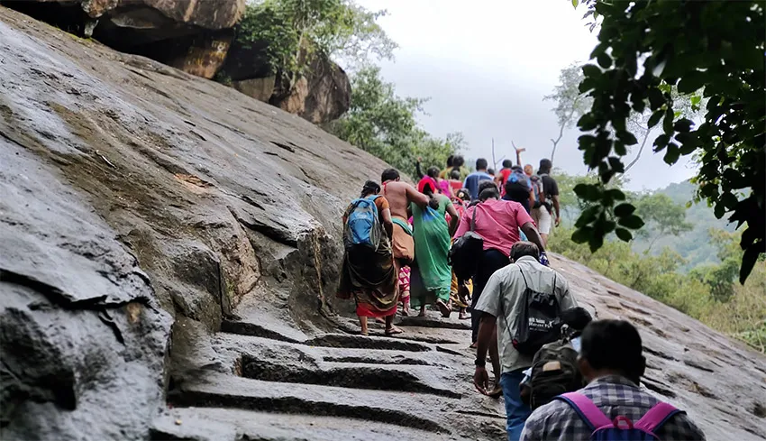
Sathuragiri trekking ranks among the most popular trekking in Tamilnadu. The uphill trek stretches for about 8 kilometres, beginning at Thanipaarai, the base of the hill. From this point onward, ashrams provide Annadhanam to devotees, while shops offer essentials such as torches, water bottles, and biscuits.
First Quarter of Sathuragiri Trekking Journey
After a walk of about half an hour, trekkers reach Kudhiraiootru. From there, the trail passes through Vazhakkuparai, which tends to be slippery, and then leads to Sangali Parai. Along the way, small streams flow gently, enhancing the natural charm.
Second Quarter of Sathuragiri Trekking Journey
Continuing beyond Sangali Parai, the path leads to Korakkar or Goraknath Cave. Thereafter, trekkers navigate through rocky terrain and water patches to reach the Irattai Lingam Cave.
Third Quarter of Sathuragiri Trekking Journey
The next stretch of the trek takes devotees to the Vanadurgai Temple, the forest’s protecting deity, and the Pilavadi Karuppasamy Temple, revered as the guardian of the hills.
Divine Darshan
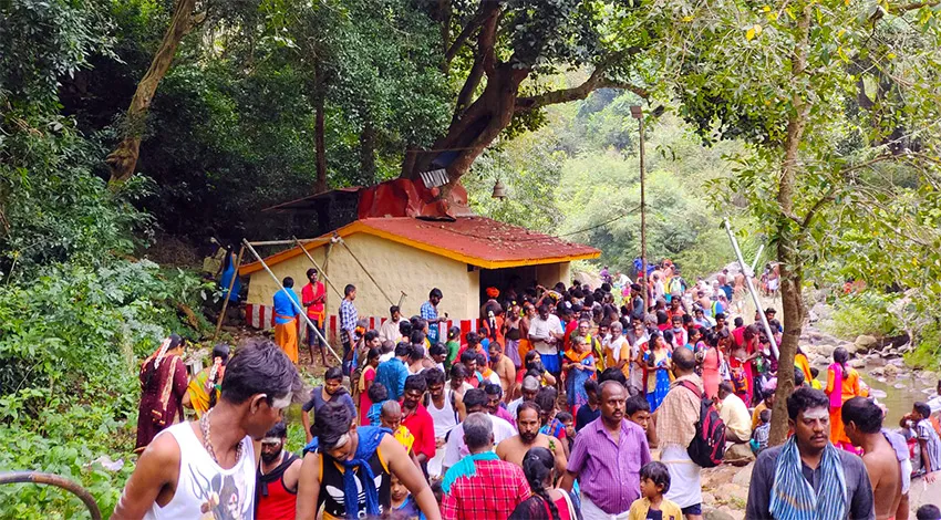
After an additional uphill walk of about 15 minutes, devotees reach the Sundara Mahalingam Temple and the nearby Sundara Moorthy Swamy Temple. Devotees regard Sundara Mahalingam as an Anidai Lingam, meaning a Lingam worshipped by Siddhas.
Behind the Sundara Mahalingam Temple stands the Anandavalli Amma Temple, where the goddess remains formless. She is believed to take form only during Navarathri. Climbing further uphill for another 15 minutes leads devotees to the Santhana Mahalingam Temple.
About 4 kilometres from the Santhana Mahalingam Temple lies the Periya Mahalingam, a massive Lingam that lives up to its name. Along the route, devotees can also worship Oonjal Karuppan Temple, Vellai Ganapathi, Nadu Kattu Ganapathi, Naga Kanni Kaavu, and Lord Ganesha at Thavasi Cave.
Essentials for Sathuragiri Trekking
Trekkers should carry water, torches, and blankets, especially if staying at the base camp. Elders often use walking sticks for support during the trek. Although ashrams provide Annadhanam along the route, it is advisable to avoid carrying food, as it attracts monkeys. Wearing flexible and comfortable clothing suitable for trekking ensures ease of movement. For elderly and physically challenged devotees, dolis (human carriers) are available. Ideally, trekkers should begin the ascent before 8:00 AM and return to the base after darshan by 6:00 PM.
Sathuragiri Temple Visiting Time
The Sathuragiri Temple opens only six days each month – three days during the New Moon (Amavasya) and three days during the Full Moon (Pournami). In addition, the temple remains open during Aadi and Thai Amavasya, when devotees gather in large numbers. Visiting hours generally range from 6:00 AM to 4:00 PM, depending on weather conditions.
Sathuragiri Routes and Distance
Thanipaarai lies about 80 kilometres from Madurai and 28 kilometres from Srivilliputhur. Srivilliputhur serves as the nearest railway station. Pilgrims traveling from Chennai usually follow the route Madurai – Srivilliputhur – Watrap – Thanipaarai. Meanwhile, pilgrims arriving from southern regions take the route Nagercoil – Tirunelveli – Rajapalayam – Srivilliputhur – Watrap – Thanipaarai.
Epilogue
A visit to the Sathuragiri Shiva Temple perfectly blends adventure with spiritual exploration. The hills offer devotees a serene environment to seek Lord Shiva’s blessings while enjoying fresh mountain air.
Ensure a safe and comfortable trek by following our complete trekking gear checklist.
Places to Visit in Srivilliputhur or Virudhunagar District
Srivilliputhur and Virudhunagar District in Tamil Nadu present a rich mix of cultural heritage and natural beauty. The Srivilliputhur Andal Temple, a UNESCO World Heritage Site, attracts visitors with its towering gopuram and historical importance. Nature enthusiasts can explore the Srivilliputhur Grizzled Squirrel Wildlife Sanctuary, which shelters rare flora and fauna.
Additionally, the Shenbagathoppu Hills offer lush greenery and scenic trekking trails, while Ayyanar Falls provides a peaceful retreat in the Western Ghats. Nearby Rajapalayam town is well known for its distinctive dog breed and weaving traditions. Visitors can also explore the bustling markets of Virudhunagar town, famous for spices and vibrant local culture. History lovers may visit the Virudhunagar Kamarajar Memorial House. Altogether, the district promises a deeply enriching travel experience.
Sathuragiri Hills Shiva Temple – FAQ
Where is Sathuragiri Hills Shiva Temple located?
Sathuragiri Hills Shiva Temple is located near Watrap in the Virudhunagar district of Tamil Nadu. It lies within the Western Ghats and is accessible through a trekking route.
Why is Sathuragiri called “Sundara Mahalingam” Temple?
The temple is dedicated to Lord Sundara Mahalingam (a form of Lord Shiva), and the hill is considered highly sacred by devotees and Siddhars who performed penance here.
Is trekking required to reach Sathuragiri Temple?
Yes, devotees must trek approximately 8–10 km from the foothills to reach the temple. The trek passes through forest paths and scenic mountain terrain.
What is the best time to visit Sathuragiri Hills?
The best time to visit is from September to February when the weather is cooler. Many devotees also visit during Amavasya and Pournami days for special prayers.
Are there any restrictions for visiting Sathuragiri Temple?
Yes, entry is regulated by the Forest Department. Visitors must follow trekking guidelines, and plastic usage is restricted to protect the forest environment.
Nearby Tourist Attractions
- Srivilliputhur Andal Renga Mannar Temple
- Grizzled Squirrel Wildlife Sanctuary
- Shenbaga Thoppu Meenvetti Parai Waterfalls
- Pilavakkal Dam, Virudhunagar
Pilavakkal Dam is located near Watrap (Vathirayiruppu), a serene village situated along the Arjuna River in Virudhunagar. district. The village derives its ancient name “Vatratha Iruppu”, meaning “place with surplus water”, which accurately reflects the region’s healthy monsoon rainfall.
Scenic Location & Purpose
Nestled at the foothills of the Western Ghats, Pilavakkal Dam serves as a crucial source of irrigation and agricultural support for nearby villages. At the same time, the dam attracts visitors as a peaceful picnic destination. Lush green paddy fields stretch across one side of the reservoir, while forested hills surround the other, creating a refreshing natural setting.
Dam Structure & Capacity
Importantly, Pilavakkal Dam consists of two divisions—the Periyar Dam and the Kovilar Dam. The Periyar Dam holds a storage capacity of 192 mcft, whereas the Kovilar Dam stores 133 mcft, together supporting regional water needs.
Connectivity & Travel
The dam lies about 55 km from Virudhunagar and 90 km from Madurai. Srivilliputhur serves as the nearest railway station, with good rail connectivity from Chennai and Madurai. Moreover, frequent buses operate from Srivilliputhur to Watrap, making access convenient.
Why Visit?
Overall, Pilavakkal Dam offers calmness, scenic beauty, and fresh mountain air, making it an ideal getaway for nature lovers and photographers seeking tranquility.
Image Attribute : Paramatamil
Bird watching in Tamilnadu offers an enriching experience for nature enthusiasts, wildlife photographers, and conservation lovers. Blessed with diverse ecosystems such as wetlands, lakes, coastal regions, forests, and agricultural landscapes, Tamil Nadu supports a wide variety of bird species. The state’s favourable climate and geography make it one of the most important birding destinations in India.
Bird Sanctuaries and Wetland Habitats
Tamil Nadu is home to numerous bird sanctuaries and protected wetlands that attract both endemic and migratory birds. These habitats provide ideal nesting, feeding, and resting grounds for birds travelling long distances. During the migratory season, thousands of birds arrive from different parts of the world, transforming these sanctuaries into vibrant centres of avian activity. Wetlands, in particular, play a crucial role in sustaining bird populations and maintaining ecological balance.
Migratory and Native Bird Species
Bird watching in Tamilnadu allows visitors to spot a wide range of species, from colourful resident birds to rare migratory visitors. Herons, storks, pelicans, flamingos, kingfishers, and raptors are commonly sighted in various regions. Each season offers a different birding experience, making the state attractive for year-round exploration. This diversity also makes Tamil Nadu a preferred destination for serious birders and researchers.
A Haven for Wildlife Photography
The abundance of birdlife and scenic natural settings makes Tamil Nadu ideal for wildlife photography. Early mornings and late afternoons provide excellent lighting and activity for capturing birds in their natural habitats. Photographers can observe birds feeding, nesting, and interacting, creating unforgettable moments in nature.
An Eco-Tourism Experience
Overall, bird watching in Tamilnadu highlights the state’s commitment to eco-tourism and biodiversity conservation. Exploring these birding hotspots offers peaceful encounters with nature while promoting awareness of wildlife protection. Whether for leisure, photography, or study, bird watching in Tamil Nadu promises a rewarding and memorable natural experience.